

- Email : saelbeih@narss.sci.eg
- Phone : 201003377582
Experience
Director of the Publishing Office of the Egyptian Journal of Remote Sensing and Space Sciences since April 2019
Associate editor in the Egyptian Journal of Remote Sensing and Space sciences (EJRS) since 2010
Reviewer in a number of International Peer Reviewed Journals
Education
Ph.D. Degree in Civil Engineering (2007). Structural Engineering Department-Faculty of Engineering-Ain Shams
University. Thesis Title: “Impact of Groundwater Recharge on the Surrounding Environment”
M.Sc. Degree in Civil Engineering (2002). Structural Engineering Department-Faculty of Engineering-Ain Shams
University. Thesis Title: “Studying the Geoengineering Hazards Using Remote Sensing Techniques and its Application on
El-Mokattam Area”
B.Sc. Degree in Civil Engineering (May 1997) “Very Good” with Honor Structural Engineering Department-Faculty of
Engineering-Ain Shams University. Graduation Project: Soil Mechanics and Foundation Engineering.
EXPERIENCE IN SCIENTIFIC PUBLISHING
Director of the Publishing Office of the Egyptian Journal of Remote Sensing and Space Sciences since April 2019
Associate editor in the Egyptian Journal of Remote Sensing and Space sciences (EJRS) since 2010
Reviewer in a number of International Peer Reviewed Journals
OTHER ADMINISTRATIVE ACTIVITIES
Member in Scientific Publishing Committee at NARSS since 2019 till now
Member in the Missions Committee at NARSS from 2011 to July 2022
Responsible for grant office in the Knowledge and Technology Transfer KTT Office at NARSS since June 2019
Registered as Expert (C) in General Organization for Physical Planning (GOPP) since Jan 2018
THESIS SUPERVISION
Ph.D. Thesis by Mohammed Abd El-Wahab Hagage. Evaluation of environmental impacts on groundwater and archaeological sites
in northeast Nile Delta, Egypt: Remote Sensing and geochemistry applications. Department of Geology, Faculty of Science, Azhar
University, (On-Going)
Ph.D. Thesis by Hala Abuel Hamd. Modeling and evaluation of landfills characterization using integrated remote sensing and
geographic information system. Ain Shams University, Faculty of Environmental Studies and Research, Department of
Environmental Engineering Sciences - Ain Shams University (On-Going)
Ph.D. Thesis by Wael Attia Hamed. Spatial Analysis of Geomorphological Hazards on the Archaeological Sites in Dakhla Depression:
A study in Applied Geomorphology using Geoinformatics Techniques. Tanta University, Faculty of Arts (On-Going)
Ph.D. Thesis by Mahmoud Saad Mohamed. Hydrogeological and Environmental Studies of the Groundwater and Surface water,
Beni Suef District, Egypt. Department of Geology, Faculty of Science, Beni Suef University, (Degree Awarded)
Ph.D. Thesis by Ebtehal Sayed Mohamed Ali. Sustainable Groundwater Management Using Solar Energy. Ain Shams University,
Faculty of Engineering, Hydraulics Engineering and Irrigation Department (Degree Awarded)
M.Sc. Thesis by Mohammed Abd El-Wahab Hagage. Impacts of anthropogenic activities on the deterioration of groundwater and
Archaeological sites in Akhmim area, Sohag Governorate, Egypt: Remote sensing and GIS applications. Cairo University, Faculty of
Science, Department of Geology (Degree Awarded)
M.Sc. Thesis by El-Sayed Abdel Sadek. Extraction of water surface and water quality of Burullus and Manzala Lakes using Satellite
data. Department of Water Resources and Hydraulics, Zagazig University, Faculty of Engineering (On-Going)
M.Sc. Thesis by Ahmed M. Bahy El - Deen. Environmental Impact Assessment for the Millionth City in Shark El-Tafriaa - Port Said
using Remote Sensing and GIS Techniques. Ain Shams University Institute for Environmental Studies and Research (Degree
Awarded)
M.Sc. Thesis by Nermeen Aziz Girgis. Urban Encroachment on Pyramids Plateau, An Applied Study Using GIS and Remote Sensing.
Ain Shams University Institute for Environmental Studies and Research (Degree Awarded)
TRAINING COURSES
Introduction to Geospatial Information Technology for Operational Planning and Decision Making in Disaster Risk
Management. 20/9- 4/10/2021. Indian Ocean Rim Association (IORA) and the United Nations Satellite Centre (UNITARUNOSAT)
1
st Scival User Group Meeting, ELSEVIER, 10 Nov. 2018
"Engineering and Geoscience Solutions from Elsevier", 18 September 2019
"Geofacets Case Studies and Engineering Solutions from Elsevier", NARSS, Cairo, 1 October 2019
Introduction to python. 5-9 Nov. 2017 at NARSS
Scientific thinking and Augmentation skills for problem solving, 28 Sept. 2017, Organized by DAAD Kairo Akademie at
NARSS, Egypt
Elsevier Info-Day Workshop on EKB Contents and SciVal. 26 April 2016
4
th International ASD Users Meeting “in Middle East” training on “Analytical Spectrum Devices (ASD) Spectroradimeter”
19-20 April 2016, NARSS, Egypt
NASA ARSET webinar Water Resource Management using NASA Earth Science Data (PM). 5 webinar sessions,13 Oct. to 10
November 2015
Radar Polarimetry, NARSS, Egypt 7- 11 Dec. 2014
Geology of Egypt, NARSS, Egypt, 21 Sept. – 1 Oct. 2014
Being an Editor for an International Journal 14 April 2014, ENSTINET, Cairo, Egypt
Artificial Neural Networks Held at NARSS, 9-11 April 2013 within the activities of SUDSOE EU-FP7 Project, Cairo, Egypt
Spectroradiometer applications (2-4 Sept. 2012) at NARSS
A Publication Workshop (5 March 2012) Organized by Elsevier at Ministry of Scientific research
Applications of Satellite Radar Technology for Development (29 Jan.-2 Feb. 2012) at NARSS by Prof. Vern Singhroy, Canada
Remote Sensing
Project Management Program PMP (5 May – 21 July 2011) Leadership and Management Development Center, Cairo
A Training Workshop on: Formulation and Writing Project Proposals, 14-17 June 2009, National Research Center, Cairo,
Egypt
“RADARSAT SAR Applications” by MDA Geospatial Services International, 14-25 May 2007, NARSS
Refresher course: “Innovative application of remote sensing and geoinformation sciences for female professionals in earth
sciences”, ITC, AARSE, NARSS, Cairo, 3-16 Nov. 2006
A package of ArcGIS 9.0 training courses by Esri conducted at NARSS as follows:
Mastering Microsoft Visual Basic, Introduction to programming ArcObjects with VBA, Advanced ArcObjects Component
Development, Introduction to ArcIMS (10 April -12 May 2005)
Working with ArcGIS Spatial Analyst, 3D Analyst and ArcGlobe,Geostataistical Analysis and Enterprise Geodatabase and
ArcSDE (30 Jan.-17 March 2005)
Introduction to ArcGIS I and II, Building Geodatabase I and II, Modeling geodatabase using Case Tools (3 Oct. 2004-2 Jan.
2005)
"Database Implementation, Visual Documentation and Image Treatment"CULTNAT, 26 May-1 June 2004, Egypt within the
Framework of the Egyptian Geological Museum Documentation Project, Smart village training center.
“Online Database Searching and Document Delivery Services” ENSTINET 19-21 Oct. 2003, NARSS
The seven modules of the International Computer Driving License Certificate (ICDL), Cairo University 24 July 2003
Remote Sensing Application in Discovering Groundwater Location, Cairo, Egypt, 14-18 April 2001.
Two days Course on Orbital Remote Sensing and its Application in Geology, Cairo, Egypt, 8-9 Jan.2001
A number of training courses under supervision of UNESO and UNDP in the Joint Project for the Capacity Building of the
Egyptian Geological Survey and Mining Authority and the National Authority for Remote Sensing and Space Sciences.
Tertiary Stratigraphy ( July 1999)
Ore Geology (10-12 July 1999)
Principles of Desert Geomorphology (4-6 May 1999)
Remote Sensing Applications (4-6 July 1999)
Structural Geology (18-20 July 1999 and 3-5 Oct. 1999)
Active Faults and Drainage Hazards (27-28 Sept.1999)
Arcview and geological Digital Maps (12 July-20 Sept. 2000)
Image Processing
CONFERENCES, SEMINARS AND WORKSHOPS
IP Strategies Workshop, 15 Dec. 2019 Organized by EKB and Derwent, Cairo
The International Workshop for Enhancement of Egypt-Japan Joint Research Projects in Egypt: Archaeology, Heritage
Sciences, Sciences ,Community and Water Management, NARSS, Cairo, 23 December 2019
15th Tunisia-Japan Symposium on Science, Society and Technology (TJASSST) Sousse, Tunisia, Nov. 29 –Dec.2nd, 2019
Geomapplica 2018 International Conference on Geomatics Applications, Syros- Greece 25-29 June 2018
Horizon 2020 Info Day, 26-27 Feb. 2018, Cairo Sheraton Hotel
5
th Egyptian–Japanese Joint Symposium on the New Valley Research Projects, NARSS, Cairo, 24
th of December 2017
International Symposium on Agricultural Meteorology
Okayama University, Japan 14-17 March 2016
Workshop on Direction of Changes in the Nile River and the Egyptian Villages Sophia University, Japan 11 March 2016
36th International Symposium on Remote Sensing of Environment, Berlin Germany, 11- 15 May 2015
20th conference on Mechanical Engineering: Development of Renewable and Water resources, Egyptian Society of
Engineers, 14-15 March 2015
International conference on Research and Innovation for Sustainable Soil Management ICRISSM 2014, Hurghada, 27-29
November 2014
The 4th Egyptian-Japanese Joint Symposium on Remote Sensing and its applications: From Archaeology to Social Sciences,
11- 12 Sept. 2012, Cairo
Regional ERA-WIDE Meeting, 9-12 July 2012, Brussels, Belgium
An International Conference on Planet Earth: Earth Sciences and Development of Civilization in Major River Basins, Luxor,
Egypt 11- 13 Oct 2010
10th International Conference on the Geology of the Arab World "GAW10", Cairo Univ., 10-12 April 2010
ISNET / NARSS seminar on Bridging the Gap through Satellite Technology, 18 – 21 Oct. 2010, Cairo
6
th International Conference on Environmental Hydrology and 1st Symposium on Coastal and Port Engineering, 28 -30 Sept.
2009, Cairo.
3
rd Egyptian-Japanese Joint Symposium Remote Sensing Applications in Archaeology, 14-15 Feb. 2009, Supreme Council of
Antiquities, Cairo
35th Annual International Conference, Association of Egyptian American Scholars (AEAS), 27-29 Dec. 2008, Supreme
Council of Universities, Cairo
Workshop on E-Learning in Higher Education, 35th Annual International Conference, Association of Egyptian American
Scholars (AEAS), 27 Dec. 2008, Supreme Council of Universities, Cairo
Workshop on Global Financial Crisis, 35th Annual International Conference, Association of Egyptian American Scholars
(AEAS), 29 Dec. 2008, Supreme Council of Universities, Cairo
International Workshop on Supercomputing Applications in Climate Sciences and Remote Sensing, 13-16 May 2008, Cairo
1
st Regional Conference on Climatic Changes and Influence on Coastal Regions, 1-2 April, 2008, Portsaid, Egypt
12th International Colloquium on Structural and Geotechnical Engineering 10-12 Dec. 2007 Cairo–Egypt
6
th AARSE International Conference on Earth Observation & Geoinformation Sciences in Support of Africa’s Development
30 October – 2 November, 2006, Cairo, Egypt
2
nd Egyptian-Japanese Workshop on “Archeology from Space”, NARSS, Cairo, Egypt (22 Feb. 2006)
FIG Workshop Week 2005 and 8th International conference on the Global Spatial Data infrastructure (GSDI-8), Cairo,
EGYPT (16-21April 2005)
International conference on future vision and challenges for urban development, Cairo, Egypt 20 – 22 December 2004
A Seminar on “Towards Actions to Implement the Transport Master Plan for Greater Cairo” organized by JICA and Higher
Committee for Greater Cairo Transportation Planning, 25/Dec.2003, Cairo
2
nd Regional Conference on Geographic Information Systems (6-7 May 2003), Cairo
First ICAMS Nile Delta Workshop on Information Technology for Coastal zone management of the Nile Delta. Stakeholder
Priorities and Needs 7-10 April 2003, Ismailia.
A Seminar on Remote Sensing and GIS Applications for Management of coastal Areas in Arab Countries, 20-23 Oct.2002,
Cairo
3
rd Workshop on Current Urban Transport Status entitled “A Challenge for Innovative Cairo Transport” organized by JICA
and Higher Committee for Greater Cairo Transportation Planning, 24 Sept. 2002, Cairo
2
nd Workshop on Current Urban Transport Status entitled “Transportation Master Plan and Feasibility Study of Urban
Transport Projects in Greater Cairo Egypt” organized by JICA and Higher Committee for Greater Cairo Transportation
Planning, 14 May 2002, Cairo
Egyptian-Japanese Joint Seminar on Space Sciences and Technology, Cairo, Egypt, 3-5 March 2002.
9
th International Colloquium on Structural and Geotechnical Engineering, Cairo, Egypt, 10-12 April 2001.
3
rd Cairo Earthquake Engineering Symposium, Cairo, 18-20 Nov. 2000.
Regional Workshop on “The Exclusive Economic Zone, Cairo, Egypt, 3-5 April 2000.
2
nd International Conference on Earth Observation and Environmental Information, Cairo, Egypt, 11-14 Nov. 2000.
International Conference on the Western Desert of Egypt: Geological and Development Potentials, Cairo, Egypt, 17-20 Jan.
2000.
PROFESSION
o Acting Head of Engineering Applications and Water Division at NARSS from August 2022 till now
o Head of the Engineering Applications Department at NARSS from July 2021 till now
o Professor at the Engineering Applications Department at NARSS from March 2021 till now
o Associate Professor at the Engineering Applications Department at NARSS from May 2014 till March 2021
o Researcher at the Engineering Applications Department at NARSS from March 2008 to May 2014
o Assistant Researcher at the Engineering Applications and Water Division at NARSS from October 2002 till March 2008
o Research Assistant at the Engineering Applications and Water Division at NARSS from June 1998 till October 2002.
o Structural Engineer Designer at Enviro Civic Consultants from September 1997 to June 1998
COMPUTER SKILLS
Very Good Skills using Microsoft Products (Windows 10, Word, Internet, Excel, Power Point,…....Etc)
Very Good skills using remote sensing programs (e.g. ENVI), Geographical Information Systems (i.e. Arc GIS).
Good skills using Mendeley Reference organizer
Publications
JOURNAL PUBLICATIONS
1- El-Fakharany, Zeinab M., Elbeih, Salwa F. (2023). Delineate potential groundwater recharge sites in West Assiut,
Egypt using remote sensing and GIS. Water and Energy International Volume 66r, Issue 5, August 2023, Pages 6-13
2- Hagage, M, Madani AA, Aboelyamin A. & Elbeih S.F. (2023). Urban sprawl analysis of Akhmim city (Egypt) and its risk
to buried heritage sites: insights from geochemistry and geospatial analysis. Heritage Science, Published: 16 August
2023
3- Abd el-sadek E, Elbeih S and Negm A. (2022). Coastal and landuse changes of Burullus Lake, Egypt: A comparison
using Landsat and Sentinel-2 satellite images. The Egyptian Journal of Remote Sensing and Space Sciences. Volume
25, Issue 3, December 2022, Pages 815-829
4- Mohammed M.S., Elbeih S.F., Mohamed E.A., Abu Salem H., Ibrahim M., ElSayed E.E (2022). Spectral Indices Based
Study to Evaluate and Model Surface Water Quality of Beni Suef Governorate, Egypt. Egyptian Journal of Chemistry.
Article in Press
5- Mohammed M.S. Mohamed E.A., Abu Salem H., Ibrahim M. Elbeih S.F, ElSayed E.E (2022). Geochemical Evolution of
Groundwater in the Quaternary Aquifer in Beni Suef area, Egypt. Egyptian Journal of Chemistry. Volume 65, Issue 12,
December 2022
6- Hagage, M., Madani, A.A. and Elbeih, S.F. (2022).Quaternary Groundwater Aquifer Suitability for Drinking in Akhmim,
Upper Egypt: An Assessment Using Water Quality Index and GIS Techniques. Arabian Journal of Geosciences. Vol.
15:196
7- Elbeih, S. (2021). Evaluation of agricultural expansion areas in the Egyptian deserts: A review using remote sensing
and GIS. The Egyptian Journal of Remote Sensing and Space Sciences. Volume 24, Issue 3, Part 2, December 2021, Pages
889-906
8- Elbeih, S., Madani, A. and Hagage, M. (2021). Groundwater deterioration in Akhmim District, Upper Egypt: A Remote
Sensing and GIS investigation approach. The Egyptian Journal of Remote Sensing and Space Sciences. Volume 24, Issue
3, Part 2, December 2021, Pages 919-932.
9- Iwasaki, E., Elbeih, S. Shalaby, A., Khedr, H. and Zaghloul, E. (2020). Wells and land use changes in Dakhla Oasis
(Egypt) using geospatial analysis: A case study of Rashda village. Euro-Mediterranean Journal for Environmental
Integration. 5, Article number: 61
10- Zaghloul, E.A., Abdeen, M.E., Elbeih, S.F. and Soliman, M.A. (2020). Water Logging Problems in Egypt’s Deserts: Case
Study Abu Mena Archaeological Site Using Geospatial Techniques. The Egyptian Journal of Remote Sensing and Space
Sciences. Volume 23, Issue 3, December 2020, Pages 387-399
11- Effat, H.A., Elbeih, S.F. (2020). A geospatial model for allocating potential urban–industrial zones in a desert: Case
study Matrouh, Egypt. Model. Earth Syst. Environ, 6, pp.2033–2046
12- Sayed, E., Riad P., Elbeih, S., Hassan A. A. and Hagras M. (2020). Sustainable Groundwater Management in Arid Regions
Considering Climate Change Impacts in Moghra Region, EGYPT. Groundwater for Sustainable Development, 11 (2020)
100385
13- Elbeih S.F., Elkafrawy S. B., and Attia W. (2019). Multi-Criteria Site Selection and Assessment of Ports in the
Northwestern Coast of Egypt: A Remote Sensing and GIS Approach. International Journal of Environmental Science
and Development. Volume 10 (10) (Oct. 2019), pp. 310-320
14- El-Zeiny A. M. and S. F. Elbeih (2019). GIS-Based Evaluation of Groundwater Quality and Suitability in Dakhla Oases,
Egypt. Earth Systems and Environment. (2019) 3:507–523
15- Sayed, E., Riad P., Elbeih, S., Hagras M. and Hassan A. A. (2019). Multi criteria analysis for groundwater management
using solar energy in Moghra Oasis, Egypt. The Egyptian Journal of Remote Sensing and Space Sciences. Volume 22,
Issue 3, December 2019, Pages 227-235
16- S. F.Elbeih and A. M. El-Zeiny (2018). Qualitative assessment of groundwater quality based on land use spectral retrieved
indices: Case study Sohag Governorate, Egypt. Remote Sensing Applications: Society and Environment. Volume 10, April
2018, Pages 82-92
17- Salwa F. Elbeih, Nehal M.A. Soliman (2015). An approach to locate and map swelling soils around Sohag – Safaga road,
Eastern Desert, Egypt using remote sensing techniques for urban development. The Egyptian Journal of Remote Sensing
and Space Sciences (2015) 18, S31–S41
18- Salwa Farouk Elbeih (2015). An overview of integrated remote sensing and GIS for groundwater mapping in Egypt. Ain
Shams Engineering Journal, 6, pp. 1–15.
19- Kato H., Elbeih S., Iwasaki E., Sefelnasr A., Shalaby A. and Zaghloul E. (2014). The Relationship between Groundwater,
Landuse, and Demography in Dakhla Oasis, Egypt. Journal of Asian Network for GIS-based Historical Studies Vol.2 (Dec.
2014) 3-10
20- Salwa F. Elbeih, Adel A. Shalaby and Ahmed M. Bahy El-Deen (2013). Water Management Problems Associated with
Urban Sprawl in Gharbia Governorate, Egypt Using Remote Sensing and GIS. International Journal of Advanced Remote
Sensing and GIS, Volume 2, Issue 1, pp. 243-259
21- Zaghloul, E.A., S.M. Hassan,A.M. Bahy El-Dein and S. F. Elbeih. (2013). Detection of Ancient Irrigation Canals in Deir ElHagar Playa, Dakhla Oasis, Egypt, Using Egyptsat-1 Data. Egypt. J. Remote Sensing Space Sci. (2013) 16, 153–161
22- Kato, H., Kimura, R., Elbeih, S.F., Iwasaki, E., and E.A. Zaghloul (2012). Land use change and crop rotation analysis of a
government well district in Rashda village – Dakhla Oasis, Egypt based on satellite data. Egypt. J. Remote Sensing Space
Sci. Vol 15 (2), pp. 185-195.
23- Salwa F. Elbeih, Abdel Aziz B. Belal and El - Sayed A. Zaghloul (2011). Hazards mitigation and natural resources evaluation
around Sohag - Safaga highway, Eastern Desert, Egypt. Egypt. J. Remote Sensing Space Sci. Vol. 14 No. 1: 15-28
24- Lamyaa Gamal El Deen Taha and Salwa Farouk Elbeih (2010). Investigation of fusion of SAR and Landsat data for shoreline
super resolution mapping: the Northeastern Mediterranean Sea coast in Egypt. Applied Geomatics (2010) 2:177–186
25- Elbeih, S. F.,Fayed A. M., Zaghloul E.A., Fekri A.M. and Mikhael N. N. (2009). Hydrogeophysical Investigations on Madinet
Habu Temple, Western Bank of Luxor, Egypt. Ain Shams Journal of Civil Engineering, Vol. 1 (March 2009), pp. 345-353
26- Eid, M.M., Abdel Rahman, M.T., Zaghloul, E.A. and Elbeih, S.F. (2006). Integrated Remote Sensing and GIS for Proposing
Groundwater Recharge Locations: Case Study at West El-Nubariya Canal, Egypt. Egypt. J. Remote Sensing & Space Sci.,
Vol.9, pp. 113-134
27- M.M,Eid, E.A.Fattah, E.A.Zaghloul,and Salwa F. Elbeih (2003). Measurement of Surface Lateral Ground Movements in the
Vicinity of the Southwestern Scarp, El-Mokattam Plateau, Cairo, Egypt. Journal of the Egyptian Geotechnical Society,
Vol.14 Pt.1 PP.1-22
CONFERENCE PUBLICATIONS
1- Elbeih Salwa F., Hagage Mohammed, Attia Wael, Abdelsadek El Sayed (2023). Using Treated Wastewater in Groundwater
Recharge at Wadi El Farigh Area, Egypt: GIS and Remote Sensing Applications. The 1st International Conference of Remote
Sensing and Space Sciences Applications 8-11 December, HURGHADA, EGYPT
2- El Sayed Abdelsadek, Salwa Elbeih, Abdelazim Negm (2023). Mapping Water Quality and Bathymetry Determination of
Burullus Lake using Remote Sensing and GIS. The 1st International Conference of Remote Sensing and Space Sciences
Applications 8-11 December, HURGHADA, EGYPT
3- Erina IWASAKI, Salwa Elbeih, Adel SHALABY, and El-Sayed Zaghloul (2019). Replacement Wells and Land Use Changes in
Dakhla Oasis (Egypt) Using Geo-Spatial Analysis: Case Study of Rashda Village. 15th Tunisia-Japan Symposium on Science,
Society and Technology (TJASSST) Sousse, Tunisia, Nov. 29 –Dec.2nd, 2019
4- Ebtehal Sayed, Peter Riad, Salwa Elbeih, Mona Hagras and Ahmed A. Hassan (2019). Groundwater Management in
Moghra region considering climate change impact. Regional Expert Workshop on Water Resources and Climate
Change: Impacts, Mitigation and Adaptation, Amman‐Jordan 03‐07 November 2019
5- Elbeih Salwa, El Kafrawy Sameh, Attia Wael (2018). Site Selection, Assessment of Ports, Harbors and Marinas, North
Western Coast of Egypt: A Remote Sensing and GIS Approach. Geomapplica International Conference, Syros & Mykonos
Islands 25-29 June 2018.
6- Salwa F. Elbeih and El-Sayed A. Zaghloul (2017). Least Cost Path and Accessibility Map for the Ancient Egyptian Pilgrimage
Track South Sinai, Egypt using Remote Sensing and GIS. Virtual Heritage Cairo’s 1st International Conference 20-21st Feb.
2017, Cairo, Egypt
7- Belal A.A., Moghanm F.S, S.F. Elbeih (2013). Evaluation of Some Agriculture Expansion Areas in the Eastern Desert, Egypt
using GIS. International Journal of Arts & Sciences (IJAS) Conference held at Hotel Ibis München City Nord, Ungererstrasse
139, 80805 Munich, Germany (23-26 June 2013).
8- Elsayed Zaghloul and Salwa Elbeih (2013). Using remote sensing and GIS techniques to monitor the geoenvironmental
changes at Abydous area, Sohag, Egypt. GEOMED 2013, 3rd international geography symposium, Antalya, Turkey, 10 – 12
June 2013
9- Elbeih, S.F., Iwasaki, E. and H. Kato (2012).Irrigation and Land Use in Rashda Village: Case Study of Well No.3 District,
Based on Satellite Data. The 4
th Egyptian Japanese Joint Symposium on Remote Sensing and Its Application; From
Archaeology to Social Sciences 11 – 12 September 2012, Cairo, Egypt
10- El-Sayed A. Zaghloul, Salwa F. Elbeih and Osman A. Hassan (2010).Assessment and Management of Water Resources in ElQaa Plain, Southwest Sinai Peninsula, Egypt.10th International Conference on the Geology of the Arab World "GAW10".
10-12 April Fac. of Science, Cairo Univ
11- S. F. Elbeih, Zaghloul, E.A.,A.M. Bahy El-Deen and Mikhael N.N. (2010). "Evaluating and Mitigating the Natural and ManMade Hazards at Madinet Habo West Luxor, EGYPT”. Planet Earth: Earth Sciences and Development of Civilization in
Major River Basins, Luxor, Egypt 11- 13 Oct 2010
12- Salim, Mariam G. and Elbeih, Salwa F. (2009).Environmental assessment of filling the Qattara Depression as a national
project in Egypt. Conveying the water through a major canal from the North of Assiut. 6th International Conference on
Environmental Hydrology and 1st Symposium on Coastal and Port Engineering, 28 -30 Sept. 2009 Cairo
13- Eid, M.M., Abdelrahman, M.T., Zaghloul, E.A. and Elbeih, S.F. (2007). Prediction of the Responses to Groundwater
Recharge: Case Study at West El-Nubariya Canal, EGYPT. 12th International Colloquium on Structural and Geotechnical
Engineering, 10-12 Dec. 2007 Cairo–Egypt
14- Qaddah,A.A. and Elbeih,S.F. (2005). GIS as A Tool For Promoting A Village. Middle East & Africa Conference for ESRI
Users MEAUC, 6-8 Dec.2005, Sharm El-Sheikh Egypt
15- Zaghloul, E.A., H.H. Elewa and S.Elbeih (2004). Urbanization Impact on the Environmental Conditions of the Coastal
Zone between El-Burullus and Port-Said, Egypt. GORS 14th International Symposium on Remote Sensing and
Development.27-30 Sept., 2004, Syria
BOOK CHAPTERS
1- Abdelsadek, E., Elbeih, S., Negm, A. (2023). Mapping Water Quality and Bathymetry Determination of Burullus Lake Using
Remote Sensing and GIS. In: Gad, A.A., Elfiky, D., Negm, A., Elbeih, S. (eds) Applications of Remote Sensing and GIS Based
on an Innovative Vision. ICRSSSA 2022. Springer Proceedings in Earth and Environmental Sciences. Springer, Cham.
https://doi.org/10.1007/978-3-031-40447-4_10
2- Elbeih, S.F., Hagage, M., Attia, W., Abd el-sadek, E. (2023). Using Treated Wastewater in Groundwater Recharge at Wadi El
Farigh Area, Egypt: GIS and Remote Sensing Applications. In: Gad, A.A., Elfiky, D., Negm, A., Elbeih, S. (eds) Applications of
Remote Sensing and GIS Based on an Innovative Vision. ICRSSSA 2022. Springer Proceedings in Earth and Environmental
Sciences. Springer, Cham. https://doi.org/10.1007/978-3-031-40447-4_8
3- Erina IWASAKI, Abdelazim NEGM, Salwa ELBEIH (2021). Sustainable Water Solutions in the Western Desert, Egypt,
Dakhla Oasis, Earth and Environmental Sciences Library Springer
4- Negm A.M., Kostianoy A., Elbeih S.F. (2020) Introduction to “Environmental Remote Sensing in Egypt”. In: Elbeih S., Negm
A., Kostianoy A. (eds) Environmental Remote Sensing in Egypt. Springer Geophysics. Springer, Cham
5- Elbeih S.F., El-Zeiny A.M., Negm A.M., Kostianoy A. (2020) Update, Conclusions, and Recommendations of “Environmental
Remote Sensing in Egypt”. In: Elbeih S., Negm A., Kostianoy A. (eds) Environmental Remote Sensing in Egypt. Springer
Geophysics. Springer, Cham
6- Nasr M., Elbeih S.F., Negm A.M., Kostianoy A. (2020) Overview for Recent Applications of Remote Sensing in Egypt. In:
Elbeih S., Negm A., Kostianoy A. (eds) Environmental Remote Sensing in Egypt. Springer Geophysics. Springer, Cham
7- Salwa F. Elbeih (2016). Mapping of Groundwater in Egypt Using RS/GIS: Case Studies, Areas Surrounding Nile Valley
and Its Delta. In The Nile Delta. Volume 55 of the series The Handbook of Environmental Chemistry pp 63-88. Springer
International Publishing
8- Elsayed Zaghloul and Salwa Elbeih (2014). Using Remote Sensing and GIS Techniques to Monitor the Geoenvironmental
Changes at Abydos Area, Sohag, Egypt. Chapter Three In: Tourism, Environment and Ecology in the Mediterranean
Region. Cambridge Scholar Publishing. Edited by Recep Efe and Münir Öztürk
Latest Events
Latest News
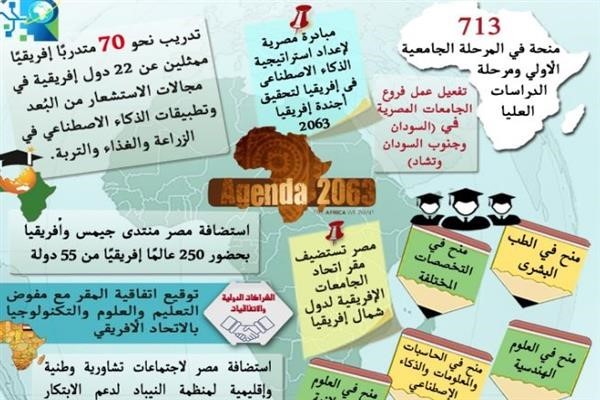
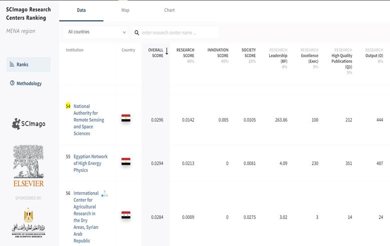
NARSS
National Authority for Remote Sensing & Space Sciences
NARSS is the pioneering Egyptian institution in the field of satellite remote sensing. NARSS is an outgrowth of a Remote Sensing Center, established in 1971 as an American-Egyptian joint project that was affiliated to the Egyptian Academy of Scientific Research and Technology
Copyright © innovaDigits 2023,all rights reserved


