Introduction
The division seeks to disseminate modern technologies (ground laser, aerial laser, radar, and hyperspectral)
The Division also carries out scientific cooperation with universities in registering for master’s and doctoral degrees
We seek to direct scientific theses and research to be applied research. We also seek to encourage international publishing and joint international publishing. We also seek to support and develop human resources and develop infrastructure (laboratories and equipment).
The Division also implements many courses through the Training Division for university students
The Division also carries out training courses in any of its fields. What is new is that the Division is opening scientific, research and applied communication and cooperation with various bodies, whether governmental represented in the various governorates or the public or private business sector. This and the Division
The division can provide any advice or advice to any party that requests it
The Division participates in research grants and capacity building grants provided to the Authority
- The Division also seeks to work on the applications of the various axes in the Egypt Plan (especially the environment and agriculture), then energy, water, and tourism - and to participate with the original specialists in these fields.
Vision
That the Aerial Photography and Aviation Division of the Authority be a distinguished center and a house of expertise in producing maps, whether detailed or thematic maps, from various sources such as aerial photography, single or stereoscopic satellite visuals, or ground surveying, and disseminating modern technologies (Terrestrial laser, airborne laser, radar, and hyperspectral).
Mission
Producing maps, whether detailed or thematic maps, using the latest technologies such as laser, hyperspectral, radar images, aerial photography, single or three-dimensional satellite visuals, or land surveying to serve sustainable development.
Division activities
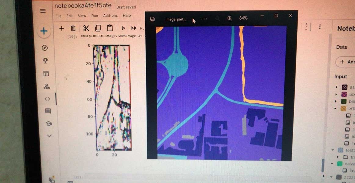
Department of Digital Mapping
- Evaluating the production of maps from various satellite images
- Extracting features from satellite visuals, digital cameras, and radar data
- Producing large-scale maps from various types of satellite images
- Data merging
-Urban remote sensing
- Producing digital elevation models from various sources (aerial lasers - aerial photographs - stereoscopic satellite images)
- Producing vertical images from various sources
- Producing base maps from various sources
- Filtering digital surface models to obtain digital terrain models
- Study of urban encroachment on agricultural lands
- Study of urban sprawl on river islands
- Processing and classifying radar visuals
- Extracting routes from satellite visuals
- Extracting buildings from satellite images
- Monitoring change
-Climate changes and URBAN HEAT ISLAND
-Urban mapping
- Remote sensing in arid and semi-arid (desertification)
Ground surveying
-Ground laser scanning
-Processing ground laser data
-Documenting tourist and archaeological landmarks
-Geoid worked for Egypt in different ways
- Ground surveying using various methods
- Extracting features from point clouds
Department of Aerial Photography and Aviation
-The role of neural networks in remote sensing
- Removing clouds from satellite images
- Extracting features from hyperspectral data
- Classifying hyperspectral data into different classifiers
-Generating digital Earth models from atmospheric lasers
- Integrating aerial laser data with digital camera data
-Producing digital surface models
- Point cloud processing for UAV
-Texture analysis
- Extracting features by classifying objects from an aerial laser
Thermal remote sensing
- subpixel classifier
-Expert System
- nero fuzzy and fuzzy
- Study of informal settlements
- point cloud segmentation
- multi classifier (classifier ensample)
- Choosing the most suitable buildings to place solar energy cells using an aerial laser
Division members
Related Projects
Latest Events

Latest News

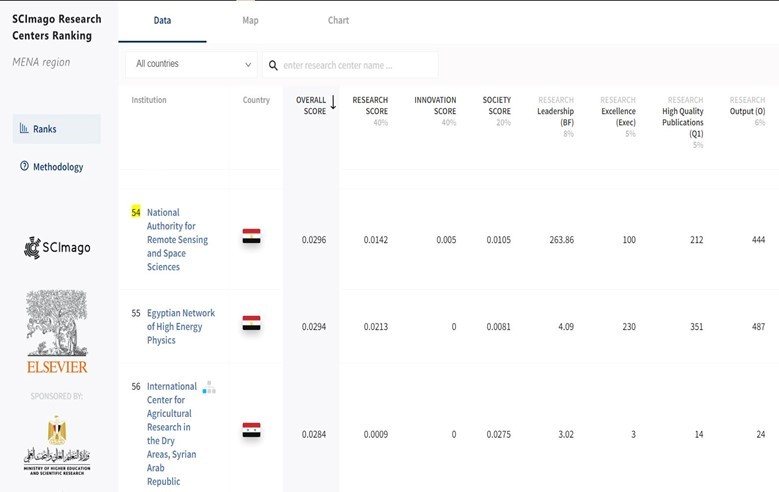
NARSS
National Authority for Remote Sensing & Space Sciences
NARSS is the pioneering Egyptian institution in the field of satellite remote sensing. NARSS is an outgrowth of a Remote Sensing Center, established in 1971 as an American-Egyptian joint project that was affiliated to the Egyptian Academy of Scientific Research and Technology


