Essential and Advanced geographic information system (GIS) for geological application (Processing and interpretation)
1. COURSE DETAIL
The course will be applied on three parts each one has a duration of 5 days , these parts detailed as following;
1. Part one
Goals
1- Exploring GIS concepts.
2- Displaying data.
Topics
• what is GIS.
• GIS functions.
• Capturing data.
• Sorting data.
• Query, Analysis, display, output.
• Organizing spatial data.
• representing data in vector data.
• Map scale.
• Component of geographic data.
• Arc-Map, Arc-Catalog, Arc-Toolbox.
•Data view and layout view.
• Layers, data frames& maps.
•Managing the table of content (TOC).
•Using a bookmark.
•Magnifier and overview windows.
•Layer symbology in ArcMap.
•Using the classification histogram.
•Changing symbol properties.
•Labeling feature.
•Scale dependant display.
•Creating a definition query.
•Saving a layer file.
Part II
Goals
1- Querying your database.
2- Working with spatial data.
Topics
•Identifying, finding, measuring.
• Map tips and hyperlinks.
• Available selection tools.
• Selection methods.
• Interactive selection option.
• Attribute selection.
• Select by location (spatial query).
• Location selection methods
• Select by graphics.
• Calculating summary statistics.
• Representing geographic features.
• Introducing feature classes.
• Linking feature and attributes.
• Spatial data formats.
• Shapefile data format.
• Coverage data format.
• ArcInfo coverafe organitation.
• Geodatabase data format..
• Tabular location to a point feature class.
• Images and grids.
• Using ArcCatalog.
• Three ways to view data.
• The contents tab.
• The preview tab.
• The metadata tab.
• Introducing metadata.
• Connecting to data.
Part III
Goals
1- Working with tables.
2- Editing data.
Topics
• Tables.
• Understanding table anatomy.
• Tabular data field type.
• Table formats and manipulation.
• Tables relationships.
• Associating tables.
• Join and relates.
• Connecting tables with join.
• Connecting tables with relate.
• Graphs and reports.
• Editable data formats.
• Navigating edit session.
• Managing edit session.
• Selecting features.
• Simple editing function.
• Edit tasks
• Create new feature tasks.
• Modifying a sketch.
• Modify feature and reshape feature.
• Extend / trim feature and cut polygon.
• Using snap.
• Editing attribute data for selected feature.
• Adding table fields.
Part IV
Goals
1- Working with georeferenced data.
2- Presenting and analysis data.
Topics
• What is georeferencing?
• Coordinate systems.
• Datum and datum conversion.
• Referencing location.
• Map projection.
• Projection distortion.
• Types of projection.
• Coordinate system components.
• Storing projection information.
• ArcMap and projection.
• Changing projection.
• Map and design objectives.
• Factor controlling cartographic design.
• Creating and setting maps
• Identify and insert map elements.
• Layout tools.
• Grids and rulers.
• Creating and using map templates.
• Printing and plotting maps.
Latest Events


Latest News

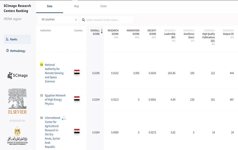

NARSS
National Authority for Remote Sensing & Space Sciences
NARSS is the pioneering Egyptian institution in the field of satellite remote sensing. NARSS is an outgrowth of a Remote Sensing Center, established in 1971 as an American-Egyptian joint project that was affiliated to the Egyptian Academy of Scientific Research and Technology


