ArcGIS Enterprise system for Remote Sensing data analysis
● Course Description:
ArcGIS Enterprise: Remote Sensing Data Management: This course covers the basics of managing remote sensing data in ArcGIS Enterprise. It covers topics such as acquiring remote sensing data, storing and managing remote sensing data, and using remote sensing data for analysis. applying image processing algorithms to remote sensing data, creating and managing image pyramids, and performing spatial analysis and classification using machine learning and deep learning enterprise algorithms on remote sensing data.
● Course Objectives:
Upon completion of this course, students will be able to:
● acquire, store, and manage remote sensing data in ArcGIS Enterprise.
● apply image processing algorithms to remote sensing data in ArcGIS Enterprise.
● perform spatial analysis on remote sensing data in ArcGIS Enterprise.
● create web maps with remote sensing data in ArcGIS Enterprise.
● use remote sensing data for environmental monitoring in ArcGIS Enterprise.
● use remote sensing data for disaster management in ArcGIS Enterprise.
● Prerequisites:
○ Introduction to Remote Sensing Using ArcGIS Software dektope
○ Basic knowledge of computer science
○ Some familiarity with enterprise systems
○ Proficiency in ArcGIS Pro: Students should be proficient in using ArcGIS Pro before taking this course.
○ Basic understanding of remote sensing: Students should have a basic understanding of remote sensing before taking this course.
● Required Software:
○ ArcGIS enterprise
○ ArcGIS pro
● Textbooks:
1. ArcGIS Enterprise: A Practical Guide to Planning, Designing, and Deploying by Esri Press. This textbook provides a comprehensive overview of ArcGIS Enterprise, covering topics such as the architecture of ArcGIS Enterprise, the design principles of ArcGIS Enterprise, and the deployment process for ArcGIS Enterprise.
2. Concepts, Methodologies, and Tools by Omar El Sawy and Ramesh Venkataraman. This textbook provides a comprehensive overview of the concepts, methodologies, and tools used in enterprise systems. It covers topics such as the different types of enterprise systems, the methodologies used to develop enterprise systems, and the tools used to implement enterprise systems.
3. Integration and Data Management by James W. Brown and Michael J. Hoffer. This textbook focuses on the integration and data management aspects of enterprise systems. It covers topics such as the integration of enterprise systems with other systems, the data management challenges of enterprise systems, and the data modeling techniques used in enterprise systems
4. A Managerial Perspective by Michael C. Marconi. This textbook focuses on the managerial aspects of enterprise systems, covering topics such as the role of enterprise systems in business, the impact of enterprise systems on organizations, and the management of enterprise systems projects.
● Course Outline:
● Module 1: Introduction to Remote Sensing: This topic will cover the basics of remote sensing, including the different types of remote sensing data, how remote sensing data is acquired, and how remote sensing data is used.
● Module 2: ArcGIS Enterprise for Remote Sensing: This topic will cover how to use ArcGIS Enterprise to manage, process, analyze, and visualize remote sensing data
● Module 3: Remote Sensing Applications: This topic will cover how to use remote sensing data for a variety of applications, such as land use planning, environmental monitoring, and disaster management
● Module 4:Image Processing: This topic will cover how to apply advanced image processing algorithms to remote sensing data
● Module 5:Spatial Analysis: This topic will cover how to perform spatial analysis on remote sensing data
● Module 6:Web Mapping: This topic will cover how to create web maps with remote sensing data
● Module 4: Case studies
● Course Delivery Method:
○ Lectures: Interactive lectures delivered by experienced remote sensing professionals and experts through presentations, videos, and demonstrations.
○ Homework Assignments: There will be three homework assignments throughout the course. The homework assignments will be graded on correctness and completeness.
○ Project: The project will involve applying machine learning to a remote sensing problem. Students will work in groups of two or three to complete the project. The project will be graded on creativity, originality, and technical quality.
○ Q&A Sessions: Regular question and answer sessions to clarify doubts and address participants' queries related to the course content and practical exercises.
● Course Duration:
4 weeks (can be adjusted as per requirements)
● Note:
The course content and duration can be customized according to the specific requirements and level of expertise of the target audience
Latest Events


Latest News


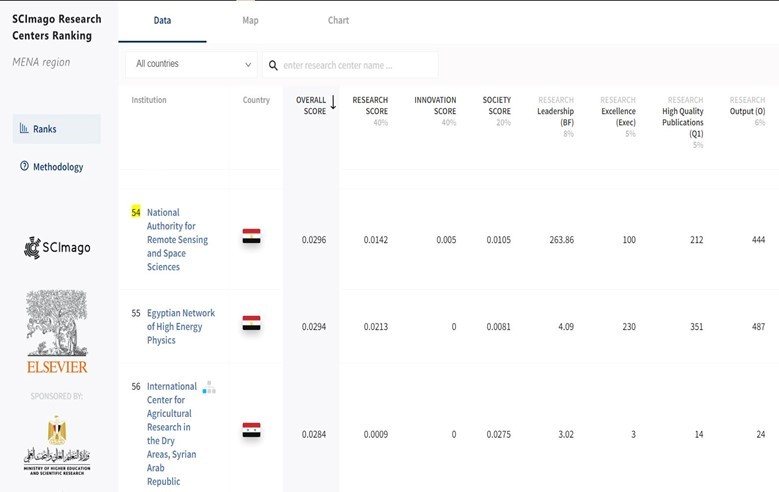

NARSS
National Authority for Remote Sensing & Space Sciences
NARSS is the pioneering Egyptian institution in the field of satellite remote sensing. NARSS is an outgrowth of a Remote Sensing Center, established in 1971 as an American-Egyptian joint project that was affiliated to the Egyptian Academy of Scientific Research and Technology


